Shutting Down CMBT Is Cruel, It Needs To Continue As Chennai’s Primary Transit Hub

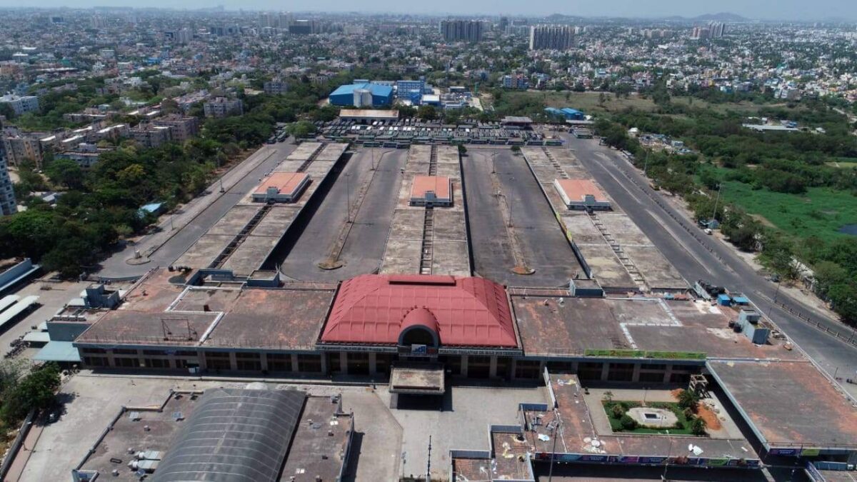
With the impending opening up of the Vandalur Kilambakkam Bus Terminus in southern Chennai, one fear among many of the city’s residents is not going away. The Chennai Metropolitan Development Authority (CMDA) has proposed to shut down the Chennai Mofussil Bus Terminus (CMBT) (also known as Puratchi Thalaivar Dr MGR Bus Terminus or MGR Koyambedu) permanently.

A little background
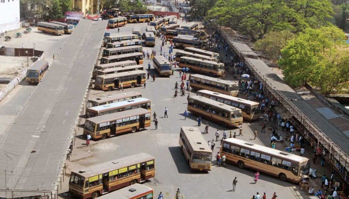
Broadway Bus Terminus. Photo Credit: Commercial Vehicles Magazine

Opened in 2002, CMBT is a 37-acre bus station that serves as Chennai’s primary terminus for mofussil and long distance buses operated by various government agencies. It is owned by the CMDA and operated jointly by the six divisions of the Tamil Nadu State Transport Corporation (TNSTC), namely TNSTC Villupuram, TNSTC Coimbatore, TNSTC Salem, TNSTC Kumbakonam, TNSTC Tirunelveli and TNSTC Madurai. The remaining two arms of the TNSTC, the Metropolitan Transport Corporation (MTC) and the State Express Transport Corporation (SETC) also play a role in the daily operations.

Prior to 2002, Chennai had no dedicated bus station for long-distance buses. Few SETC buses usually operated out of one half of the Broadway bus terminus. Other SETC and nearby states’ buses would operate out of a vacant plot of land opposite Chennai Fort railway station, which today houses the Government Dental College and Hospital while private buses would operate from the Gandhi-Irvin Bridge Road near Chennai Egmore railway station on the banks of the Cooum river.

In the late 1990s, the wholesale market located at Kothawal Chavadi was moved to a 295 acre plot in Koyambedu. After this, the entire operations of all government buses was shifted to the new bus terminus at CMBT. A separate 6.7 acre bus station was built across the road, adjacent to the whole market. Named the Chennai Contract Carriage Bus Terminus (CCCBT), it handles between 350 to 450 private buses and 5,000 passengers a day.

Till 2018, CMBT was the hub for all TNSTC and SETC buses, as well as buses operated by the RTCs of Puducherry (PRTC), Karnataka (KSRTC), Kerala (also KSRTC), Andhra Pradesh (APSRTC), and Telangana (TSRTC). In 2018, TNSTC buses bound for Telangana and Andhra Pradesh, as well as APSRTC and TSRTC buses were shifted out to Madhavaram Mofussil Bus Terminus (MMBT).

Madhavaram has its problems
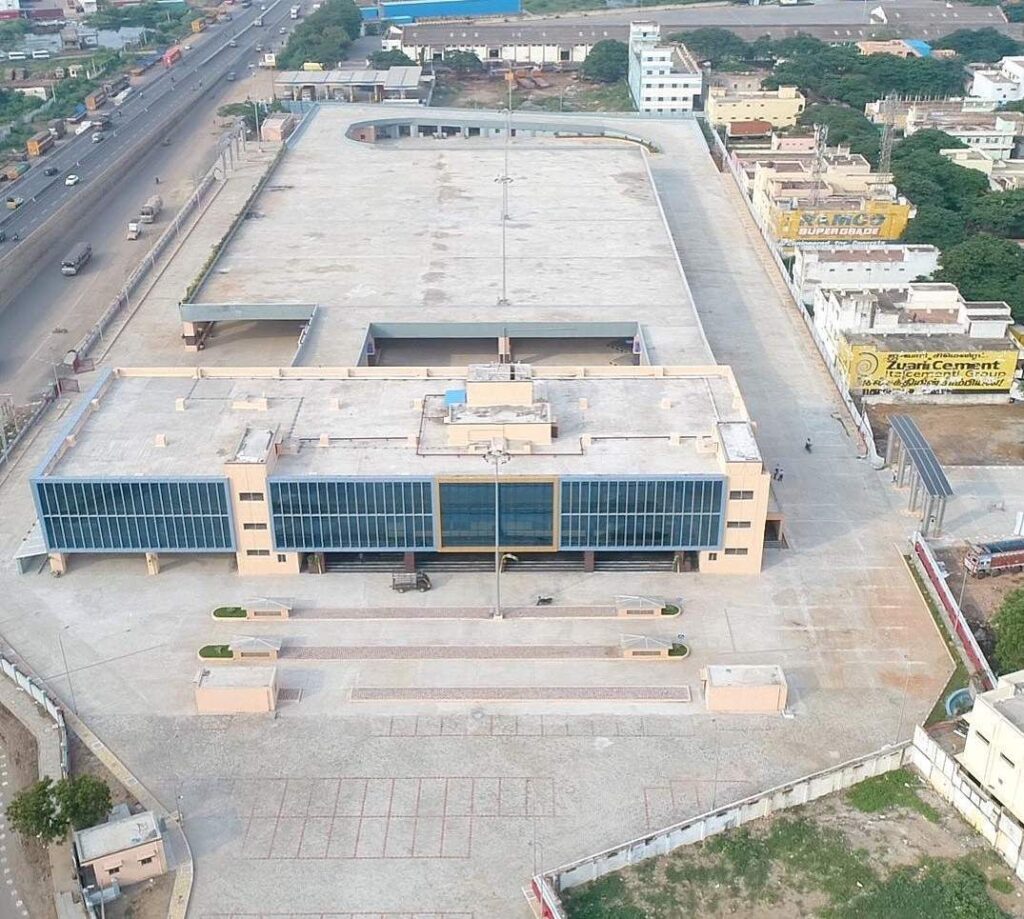
Madhavaram Mofussil Bus Terminus (MMBT). Photo Credits: BNR Infrastructure

MMBT is an 8 acre, two-level bus terminus located at Madhavaram, adjacent to CMDA’s truck terminal, at the intersection of Grand Northern Trunk Road (GNT Road) that forms National Highway 16 (formerly NH5) and Inner Ring Road (IRR/State Highway 2). While it does feature two platforms for MTC buses, it otherwise lacks good connectivity. There are a few buses that connect it to CMBT and a lot of buses that connect it to Broadway or Vallalar Nagar (V Nagar/Mint Street). Passengers arriving from CMBT have to cross the road at the roundabout which witnesses heavy truck traffic. While MMBT and CMBT are located barely 10km apart, it can take up to 30-40 minutes to reach there.

Around 315 buses use the terminus daily, catering to an average of 12,000 passengers, with a higher number over the weekends. While TNSTC and APSRTC operate numerous services to Andhra Pradesh, TSRTC operates one Volvo service to Hyderabad. APSRTC operates several buses to Vijayawada. There are no buses to Visakhapatnam or Yanam and SETC doesn’t operate a single bus into either Telugu-speaking state. In fact the destination with the highest number of SETC routes apart from Chennai is Bangalore.

MMBT can handle 42 buses on the ground level and another 50 from the upper level. However, only government buses currently operate from MMBT while private buses continue to operate from CCCBT. This puts the former, especially APSRTC buses at a major disadvantage. Interestingly, some of TNSTC’s buses bound to Tirupati start from CMBT, which also gives it an unfair advantage over its Andhra Pradesh counterpart.

Connectivity to Madhavaram will eventually improve drastically. The under-construction lines 3 and 5 of the Chennai Metro both start at Madhavaram Milk Colony, located to the northeast of MMBT with Line 5 have a station outside MMBT. It will further continue on IRR and meet the Green Line at Koyambedu (not CMBT) and then at Alandur before meeting the MRTS at St Thomas Mount/Parangimalai. While the Chennai Metro Rail Limited (CMRL) expects all three lines of Phase 2 to be completed by 2025, our friend TheMetroRailGuy estimates it to be completed no sooner than 2028.

Now coming to Vandalur Kilambakkam

While CMBT is currently Asia’s largest bus terminus at 37 acres, it will be soon dwarfed by the Vandalur Kilambakkam bus terminus that is spread across a whopping 88.5 acres. A timely reminder here that Delhi’s Millenium Park is not a bus station but a depot and therefore not Asia’s largest bus station.

With a total built-up area of 6.4 lakh square feet, it will feature 215 bus bays of which 130 will be for government buses and 85 will serve private buses. It will also have parking space for 300 buses, 275 cars and over 3,500 two-wheelers. An MTC terminal is being built adjacent to it, spread over 7.4 acres, nearly the area of MMBT. Interestingly the entire bus terminus lies within a protected and prohibited zone of the Archeological Survey of India (ASI) as it contains Megalith Burial Sites. The National Monument Authority (NMA) gave a green signal so long as no commercial development took place for 100m in the region except for greenery and the CMDA installed the required signage.

By road, the distance between CMBT and Kilambakkam is exactly 30km if one were to take IRR till Kathipara and then continue onto Grand Southern Trunk Road (GST Road). The distance is the same if one were to go to Maduravoyal and take the Chennai Bypass till Irumbuliyur and then proceed along GST Road. Outer Ring Road (ORR) terminates on GST Road just north of the bus station. The nearest railway stations are Vandalur and Urapakkam on the Southern Line of the suburban railway, both of which are at least 10 minutes away. As for Metro, the nearest station is Chennai International Airport, located 16km away. After a long tussle between the Highways Department and CMRL, an extension of the Blue Line from Airport to Kilambakkam is on the map. The former wanted to build an elevated corridor on the route and the metro’s height will be decided accordingly. However, this will take several years to reach fruition and till then there will be heavy traffic. CMRL has also initiated feasibility studies to extend Line 3 (Madhavaram Milk Colony to Siruseri) to Kilambakkam via Kelambakkam (Get ready for more confusion). However this is light years away since the depot is at Madhavaram and most of the line runs underground and without a depot connection, nothing can happen.

One theory that I have heard is that private players would lobby the government to let them continue operating at CCCBT. This would put all TNSTC services at an unfair disadvantage and would hurt the poorer sections of society the most. Further, GST Road is the most congested highway in Chennai since it acts as a gateway to the entire south from Coimbatore to Madurai to Trichy to Tirunelveli and Nagarcoil. The time saved by buses in exiting the city will be lost in reaching the terminus. Auto and cab fares will end up costing the same as an intercity luxury bus ticket while bus journeys with luggage in MTC buses would be unbearable.

The worst hit would be commuters towards the West: Those heading to Vellore, Bangalore, Hosur, Krishnagiri, Dharmapuri and even Salem, Erode and Coimbatore. Passengers living in North Chennai will also be affected badly. The bus journey from Bangalore which takes approximately six hours from Shantinagar to CMBT will go up by at least an hour and then there is the extra hour lost in getting to Chennai city itself.

Note: Bangalore-bound passengers won’t have to travel to Kilambakam at all. But it’s worse. Read the update section at the bottom of the post please.

The way ahead

The way ahead for CMBT isn’t all that difficult. It currently has connectivity to most parts of Chennai thru MTC buses, has a metro connection to both the major railheads (MGR Chennai Central and Chennai Egmore) and the airport.

Among the various proposals for the land, the most ridiculous one is to build a park. While I won’t deny that parks are important, the city is home to 632 parks as of 2019. The city’s per capita green cover stands at 8.5 square metres, just short of WHO recommendation of 9 square metres. In 2019, the began an ambitious plan to set up 67 new parks, mainly due to the destruction of close to one lakh trees in 2016 due to Cyclone Vardah.

CMBT can remain a bus terminus, albeit with some redevelopment. CMRL is in the process of redeveloping Broadway as a multi-storey bus terminal. MTC has been toying with this idea for the Thyagaraya Nagar (T Nagar) bus terminus for years now. CMBT could easily be redeveloped with a bus station at the ground level, parking and commercial operations above that. Bangalore has successfully done this. The Shantinagar bus depot was converted into a bus terminus with a Big Bazar and a parking lot atop the bus station back in the early 2000s. In fact, even the Kalasipalayam bus terminus, used mostly by private buses has been redeveloped in such a fashion. With bus and metro connectivity, the land will be premium, and give the CMDA a significant return on investment that can be used elsewhere.

There is no requirement for CMBT to shut down. Broadway didn’t shut down when CMBT opened up and in fact some SETC buses for Madurai still depart from Broadway. Many cities operate with multiple bus terminals. Mumbai has five outstation bus terminals while Pune has three. Bangalore has three and its central bus station, the Kempegowda Bus Station at Majestic was briefly downsized for metro construction. In the interim, certain buses were moved to Shantinagar and Mysore Road Satellite Bus Station at Bapujinagar. Today all three operate successfully.

But perhaps the most radical of all ideas came from a friend on Twitter, Krishnan. He tweeted that the site could be used for a future High Speed Rail terminal, and I could not agree any more. Given that the first HSR line to Chennai will connect it to Bangalore, it makes sense to keep the terminal somewhere near Poonamalle High Road/Grand Western Trunk Road (GWT Road). Given CMBT’s nature as the city’s pre-eminent transport hub, it makes perfect sense to make CMBT the HSR terminal as well. It will aid in quick commutes, fast transfers between different modes of transport, and will not hurt passengers’ wallets or watches.

Update

It’s 2024 and Kilambakkam (now nammed Kalaignar Centenary Bus Terminal or KCBT) is operational. While I haven’t been there, things aren’t smooth. MTC buses bound for KCBT are taking a minimum of an hour to reach there from Velachery. One good thing is 21G (Broadway to Vandalur Zoo) has been extended to KCBT, especially the AC bus but there are no AC buses from CMBT.

Private buses have refused to ply from KCBT and CMDA and the transport department has threatened to file criminal cases against them. Some buses were even forced to run empty from CMBT to KCBT. You can read more here. Southern Railways meanwhile has begun work on a new station which will take time to complete. On this note, do read: Urban Connectivity Chaos: People Managing Metro, Railway, Bus Stations Are Working In Silos by Srikanth Ramakrishnan on Swarajya.

For Bangalore and other West-bound passengers. It seems the powers that are have decided to make things worse for us. We will have to depart from another bus terminus, this time at Kuthambakkam near Thirumazhisai. This 25-acre bus terminus is touted to be completely air-conditioned and will feature a food court. The downside? It’s worse located than KCBT. It is approximately 9km from the Poonamalle junction and 2.5km from the highway. Getting there will obviously be a mess. It will feature 136 bus bays and CMDA is in the process of identifying access roads to be built. The Chennai Unified Metropolitan Transport Authority (CUMTA) has asked for an extension of the metro to start work. This line, connecting Poonamalle too Light House is under construction and connects with the existing network at Vadapalani.

Let us pray that the administration does not miss this opportunity.

Featured Image: Chennai Mofussil Bus Station (Seshadri Sukumar/PIB Chennai)

Loading

Flattr this!

From Ferry Tale to Ferry Go Round

Ferries. No, not Fairies. And most certainly, not them Purple Faeries.

Water transport is something that defines most coastal cities. New York has one of the most comprehensive Water Transport networks. In India, Kerala, with its backwaters, has a huge Boat-based transport network. Kochi even has an integrated, Road-Rail-Water Transit Hub in the form of the Vytilla Mobility Hub.

Now, when I talk of water transport in this article, I’m talking of Boats and Catamarans. Higher-end vehicles like Hovercrafts will be dealt with separately. I am mainly talking of passenger traffic, since I’m looking at it from an Urban perspective.

Union Minister for Shipping, Road Transport and Highways, Nitin Gadkari has repeatedly called for greater emphasis on water-based transport.  This resulted in the passing of the National Waterways Act, 2016. The fundamental reason behind this being the fact that it is cheaper. However, there are multitude of other reasons that work out in favour of water-based transport over road or rail.

Ferries, can run faster than trains, which run faster than buses. Ferries can carry a greater load of people than buses and and in the long run are more reliable. Will the Electronic Boat recently launched by Prime Minister Narendra Modi, it’s high time, India took up water based transport seriously.

Now, the focus of this post is going to be on four specific cities; Mumbai, Chennai, Pune and Ahmedabad, mainly because of my experience in them. They can emulated to other cities too, such as Hyderabad and Bengaluru.

The Kerala State Water Transport Department owns and operates boats and ferries as well as the infrastructure. The Maharashtra Government started planning for this in the right way by getting the Maharashtra State Road Development Corporation and Maharashtra Maritime Board to set up the necessary infrastructure, while private agencies would operate the services.

Mumbai

BEST Ferry across the Manori Creek.
BEST Ferry across the Manori Creek. Image copyright Nichalp, CC-BY-SA 2.5 Generic, available on the Wikimedia Commons.

Mumbai, as stated earlier, has several rivers flowing through the city, as well as in the vicinity. The Mithi, Oshiwara, Poisar and Dahisar lie entirely on the island, while the Ulhas River flows around the island.

Barring the stretch which passes under the runway of the Chhatrapati Shivaji International Airport, the Mithi, once dredged, cleaned of toxic sludge, as well as encroachments, can provide connectivity from Terminal 2 of the airport, Marol, and Seepz Village. Similarly, the Oshiwara can provide connectivity from Oshiwara Depot to Oshiwara Station, the Poisar from Poisar Depot to Malwani, and the Dahisar river can connect Ram Mandir in Borivali to the Dahisar Bridge Bus Station. The major hurdles on this stretch would be clearing encroachments, widening the river, dredging it, and ensuring that pollutants don’t enter it. Another major hurdle would be to demolish low lying bridges and have them replaced by higher ones.

The Ulhas river, which meanders through the Pune, Raigad and Thane district, empties into the Thane Creek. The towns of Kalyan-Dombivali, Karjat, Neral, Badlapur, and Ulhasnagar lie on the banks of the Ulhas. In rural pockets, the Ulhas provides water for agriculture. The rest of it, is filthy, much like the Mithi. Back in 2014, a Shiv Sena MP has asked the MMRDA to conduct a feasibility study for Water-based transport from Kalyan to Mumbai and Virar using the Ulhas river. If planned properly, this can link the far flung town of Karjat to the Versova Bridge via the above mentioned cities and Reti Bunder, thus making travel in the MMR easier. This has been notified as National Waterway 53.

Periodic maintenance of these water bodies will also help prevent another 26th July in future.

Today, the only existing mode of transport is in the form of boats and catamarans connecting Ferry Wharf and Gateway of India to Elephanta Island, Rewas, and Mandwa on one side, and Madh Island, Marve, Manori. The former is operated by private bodies while the latter is operated by BEST.

Chennai

The city of Chennai, has two major rivers and one canal linking these two. The Cooum river runs on the north of the city, the Adyar through the Central portion,and the Buckingham Canal connects to two while also providing connectivity to Kakinada in the North and Cuddalore in the South.

The Cooum, passing through the fringe areas of the Core city, such as Poonamallee, Maduravoyal, Koyambedu, Anna Nagar, Kilpauk, Egmore and Park is polluted for most of the year. The Adayar, passes through less denser areas such as Ekkaduthangal, Adayar, Mylapore, Guindy, etc and is less polluted.  It also passes beneath the Runway of the Chennai International Airport. The Buckingham Canal, meanwhile is relatively cleaner in the Northern fringes of Chennai, and south of Thiruvanmiyur. The section between the two, mostly passing through Central Chennai is pretty much unnavigable because of two reasons: Chennai Central station sort of sits on top of the Canal; The pillars of the MRTS line almost eat away the canals width.

The remaining section of both rivers and the Canal can be utilised for transport in and around the city of Chennai.

The Cooum, by virtue of running parallel to both Poonamallee High Road for most of its part and partly with the Egmore-Beach Railway track, can decongest both the road and the track, as well as the upcoming Metro. The Adayar can connect the Airport, Nandambakkam, Ikkaduthangal, Little Mount, Kotturpuram, Adayar, and terminate at the Theosophical Society.

The Buckingham Canal, on the other hand, can connect Ennore, Wimco Nagar with Basin Bridge on the North, and Thiruvanmiyur to Lattice Bridge, Kannaki Nagar and Sholinganallur in the South. Part of this is part of National Waterway 4.

Like Mumbai, Low Level Bridges would need demolition, the entire water bodies widened and reinforced, and dredged. Periodic maintenance would prevent Chennai from being inundated like in 2015.

Pune

The city of Pune has three major rivers flowing through it, The Mula, The Mutha and the Pavana. The Pavana flows through Northen Wakad, and Chinchwad before merging into the Mula at Kasarwadi. The Mula flows north of Balewadi, separating Pune from Pimpri-Chinchwad at Aundh and Khadki. The Mutha flows from Warje towards Deccan and Shaniwarwada, separating Old and New Pune. The Mula and Mutha meet each other at Sangamwadi from where they flow as the Mula-Mutha.

All three rivers feature a few low lying bridges, most predominantly on the Mutha, which would need be demolished.

The Mula can provide connectivity from Hinjewadi, Wakad, Balewadi, Aundh, Khadki, to Sangamwadi. The Pavana can connect Punawale, Ravet, Chinchwad, Sangvi and Kasarwadi. The Mutha can connect Warje, Kothrud, Karvenagar, Erandwane, and Shaniwarwada. From Sangamwadi, they can provide connectivity to Koregaon Park, Kalyani Nagar, Mundwa, etc.

Ahmedabad

Sabarmati Riverfront Project.
Sabarmati Riverfront Project. Image copyright Harshit Gohil, CC-BY-SA 3.0 Unported, available on the Wikimedia Commons.

Possibly the best city in India in the matters of Riverine management, Ahmedabad stands out in an interesting way. It is possibly the only city in India without low level bridges, and doesn’t need dredging.

The Sabarmati River, which originates in the Aravalis of Rajasthan, runs dry for most of the year. The Sabarmati Riverfront Development Project, under the Ahmedabad Municipal Corporation, involved construction of a concrete wall and concrete basin for the river within the city limits, to control its course, as well as facilitate easy maintenance. Part of the river width was reduced to provide for a Promenade and a Riverside Project. There are barrages at regular intervals on the river to regulate the flow of water. The river receives its water via a canal which brings water from the Narmada river at the Sardar Sarovar Dam. This Narmanda Canal flows under the Sabarmati River at their meeting point.

The Riverfront extends to The Torrent Power Park in the North and near Khodiyarnagar in the South. Plans are afoot to further extend it up North to Gandhinagar via GIFT City. There are two Boating Stations on the banks, used for joyrides on the river. This can be converted into a serious transport station, which in future can be extended up to Gandhinagar.


This article was mainly to highlight inner-city, river-based transport options. The benefits of running transport ops are it would help keep the river clean, and keep water flowing, thus, reducing chances of deluges.

Loading

Flattr this!

Chennai Floods: What do we learn?

Ten years ago, Mumbai was flooded. Rains wreaked havoc on the Financial Capital of India.

Today, ten years later, Chennai faces the same onslaught of water. It seems weird that at a time when farmers are committing suicide in Karnataka and Maharashtra, because of drought faced, people are dying in coastal Tamil Nadu and Andhra Pradesh due to floods. Water, water, everywhere, but not a drop to drink. Water, water everywhere, every drop is out to kill me. In the last decade, Mumbai has shut down for atleast one day, every year, in June, July or August due to the rains. Chennai has experienced rains in two sets this winter. One was in November, and one, in December. I’m gonna treat these two as separate instances and then draw a conclusion between two two.

November

Rains struck Madras in November 2015. It was heavy, taking the city by shock [I refrain from using the word surprise here]. Nobody expected these kinds of rains. Around 180 people died, the Central Government sanctioned ₹900crore. Chennai Police officers and Chennai Corporation workers worked tirelessly, day-and-night to help ease the situation. Ola, offered boats to those stranded, while UrbanClap announced free pest-control and OYO Rooms offered rooms ar discounted rates to shelter those who were stranded. 200 people lost their lives in this tragic incident.

December

Rains struck Madras on 1st of December. This time, Nature, really came down on the city like hell. 200 people lost their lives. The Army, Navy, Air Force and National Disaster Response Force [NDRF] were deployed in no time. Water levels reached the first floor in several localities, the Adyar and Cooum were overflowing, indundating the Saidapet, while the Palar was inundating the East Coast Road near Kalpakkam. To help the issue, CMRL continued operations of the Chennai Metro throughout the night. Madras Christian College, SRM University, Sathyam Cinema, Forum Mall Velacheri, among others offered shelter to those stranded. People were offering shelter and publicly posted this along with their phone numbers on Twitter and Facebook. The good folks at Twitter India were busy retweeting people who added #ChennaiRains to their tweets. Some good Samaritans like Harshita Murali, compiled a list of whom people could get in touch with if they were in Trouble. My friend and fellow OpenStreetMaps geek Arun Ganesh came up with a Crowd-Sourced Map that enabled people to report which areas were flooded, in order to help coordinate rescue and relief efforts. One Hotelier even offered rooms outside of Madras on a Pay-for-Food basis.

Observations
Media

As always, our national media hasn’t bothered. They’re more bothered about ‘Intolerance’. They’ll cover Paris, but not Madras. As I had stated earlier; for our media:

  • Floods in Madras, Bangalore, Hyderabad, Coastal Andhra Pradesh: Don’t care, South India isn’t important.
  • Floods in Bombay: Failure of BJP and Shiv Sena in the MCGM.
  • Floods in an NDA state: Corruption.
  • Floods in a non NDA state: Nature’s Fury.
  • Floods in Delhi: National Calamity.

Of course, the media did eventually cover it, but it was pathetic. The Hindu tried to pass off pictures of a 2013 deluge inside Delhi Airport as Chennai Airport while CNN-IBN reportedly abused the #ChennaiRainsHelp hashtag with their spammy news.

NDTV went a level higher stating that Chennai Airport is doomed to suffer because its runway is built on a river. I don’t know where these retards and morons studied English and Journalism from, because the runway is not ON a river, but a bridge built OVER the Adayar river. Chennai is not the only city in the world to have done this. The taxiway at Mumbai Airport was extended across the Mithi river in the form of a bridge too. This is common abroad as well.

Social Media

Like always, Social Media has always been the most useful. Chennaiites, have helped each other by offering shelter, food, and what not. People are sharing addresses and phone numbers on email to hep each other find shelter and get help.

Government

At the state level, Police, Fire and Municipal officers are doing their level best to coordinate rescue efforts. MTC and CMRL are running services as much as possible. At the central level, the Armed Forces and NDRF have been deployed. Indian Railways has offered all possible help as well. BSNL is offering free local and STD calls, free SMS, additional 100mb free data for Mobile and Landline users, Rent Rebate for 7 days and an extension of billing cycles by a fortnight. The Central government is doing a lot, Karnataka donated ₹5crore, which TN rejected. Apparently AIADMK workers are now stopping relief material entering to stick Amma stickers on them.

Others

Ola, OYO, and other private companies have shown their humanitarian side, while Sathyam Cinemas, Forum Mall, SRM University et al have opened their doors for the stranded. Zomato is offering food packets as well.

Skeptics

I read about a week ago, about a person who was criticising Ola and Uber, calling the Ola boats a publicity stunt. He claimed that if Ola and Uber had operated services during the floods people would not be stranded. He also stated that MTC drivers, should be thanked for continuing thru the downpour. I believe this is a bit harsh. If it rains, smaller cars would would get inundated. Back in 2005, people in Bombay died because their cars were inundated and the ACs spewed toxic fumes or their doors and power windows got jammed. BEST buses, especially Double Deckers were saviours back then.

Some skeptics, including journalist Sagarika Ghose and IPS officer Sanjiv Bhatt chose to politicise/communalise the issue with talk of Hindu-Muslim and Cows. I guess unless they are stranded in the rains themselves, they will not learn.

What can you do, if you are stuck, or you can offer support?

  1. Contribute to Arun’s map above if you can.
  2. Coordinate with Harshita [linked above] on Twitter or Medium and share details.
  3. Do not forward images on Whatsapp. Last week, some News Channels were showing images of a flooded city in China, claiming it was Chennai.
  4. Contribute to the Zomato fund, or some other cause. There are people donating Power Banks to Chennaiites.
  5. Stay indoors, stay safe. You do not know what can hit you, bite you, suck you in.
  6. AVOID RUMOUR MONGERING and DO NOT PANIC OR CAUSE PANIC.
  7. If you are on Twitter, and you have something to share, use #ChennaiRains, #ChennaiRainsHelp and tag @TwitterIndia or @The_Hindu in it.
What can we learn from this?
  1. Every city needs to be prepared for such incidents. A strong Disaster Response team needs to be set up at a local level.
  2. Coastal cities, namely Chennai, Mumbai, Mangalore, whole of Goa, Kerala, Vijayawada, Puduchery need to get together and find new ways to pump out storm water.
  3. Interlinking of Rivers must be taken a lot more seriously now.
  4. This must be a wake-up call for illegal, irregular, unathourised constructions. Chennai would not have been affected to this level if it hadn’t been for the screw-ups done by the Corporation of Chennai, Chennai Metropolitan Development Authority and Directorate of Town Planning.
  5. Lakes and river beds must be cleaned, desilted.
  6. Storm water drains need to be redesigned.

Having experienced the Floods of 26th July 2005, I know how it feels to be stuck in the rains. Be brave Chennai, if Mumbai could survive, so can you.


Updates


Chennai Floods IndiChange Participant

Loading

Flattr this!