Shooting a Bullet from Mumbai to Ahmedabad

The Bullet train is an often talked about thing these days, for good reasons too.

Officially known in Japan as the Shinkansen, meaning “New Trunk Line”, the Bullet Train got this name because of the shape of the train which initially resembled that of a bullet.
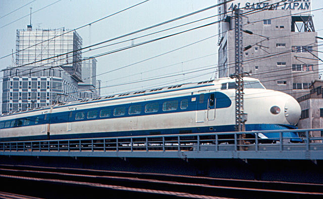
The original Shinkansen 0 Series 'Bullet Train' in 1967.
The original Shinkansen 0 Series ‘Bullet Train’ in 1967. Image copyright Roger Wollstadt, CC-BY-SA 2.0 Generic, available on the Wikimedia Commons

Of course, there are many detractors, all with pointless reasons to oppose the project. Some say it is financially nonviable, some say that it is redundant in the age of air travel, some say it will be expensive to travel on.

Let’s just go thru the Shinkansen that operates in Japan, and compare it with India.

Proposals for high speed rail had been going on since the 1930s. Prior to the Shinkansen, Japan’s rail system consisted of 1067mm Narrow Gauge railway lines which took roundabout routes due to difficult terrain. In 1957, the 3000 Series SE Romancecar, capable of attaining a record breaking high speed of 145km/hr for  Narrow Gauge was introduced. Banking on the success of an NG train achieving such speeds, Japan decided to build a High Speed Rail system that would run on a 1435mm Standard Gauge track.

With Government sanctions secured in the end of 1958, Construction began at the end of the first quarter of the following year [April 1959]. The cost then was estimated to be ¥200billion, which came in the form of Government loans, Railway Bonds, and a low-interest World Bank loan of $80million. The 550km line from Tokyo to Osaka was thrown open in October 1964 for the General Public, just before the Tokyo Olympics. The existing Limited Express train covered the distance in 6hours and 40 mins. At 210 km/hr, the Shinkansen took four hours for the same, a journey which then took 3hours by 1965 thanks to increased speeds. Today, the line is capable of handling a high speed of 285km/hr, thereby reducing the journey time between the two cities to 2hours and 22minutes!

The fare from Tokyo to Shin-Osaka is ¥14,104 for adults on the Hikari and Kodoma services, and ¥14,450 on the faster Nozomi service. This translates to roughly ₹7715 and ₹7,911 respectively which works out to an average of 25 yen per kilometre, or 14 rupees per kilometre.

Now what does the Shinkansen have that makes it so fast?

Route

All Shinkansen tracks, while at grade for most part, do not have any crossings with roads. They are completely grade separated, have tunnels and bridges thru obstacles and rough terrain, and are cut off from the regular tracks. This means, that slow trains, freight trains, all have no impact on the Shinkansen. This would make it a super win-win situation in Mumbai itself because of the severe congestion on the Western Railway network.

Track

Shinkansen track at Toyohashi station.
Shinkansen track at Toyohashi station. Image copyright Tennen-Gas, CC-BY-SA 3.0 Unported, available on the Wikimedia Commons.

Shinkansen tracks are 1435mm wide in comparison to the Japanese Narrow Gauge of 1067mm. India traditionally uses 1676mm Broad Gauge on Indian Railways. Metre Gauge tracks of 1000mm width are slowly being phased out in favour of Broad Gauge, also known as Indian Gauge. Line 1 of the Kolkata Metro and the Red, Yellow and Blue Lines of the Delhi Metro are rapid transit systems in India that run on Broad Gauge, while all other Rapid Transit Systems use the 1435mm Standard Gauge. The Shinkansen network uses a combination of both ballasted as well as ballastless tracks, with the latter being used in sections such as viaducts and tunnels.

Signalling

Automatic Signalling is used. All operations are automated at a Central Control Room, eliminating trackside signals that are used conventionally. As of now, advanced signalling is only used on Metro corridors in India.

Traction

The Shinkansen operates on a 25kiloVolt Alternating Current system of electrification. This is the same as Indian Railways and most Metro Railway projects, thus making it the simplest of Shinkansen features to implement in India.

Trains

All trains are Electrical Multiple Units [EMUs]. They are lightweight and air-sealed for greater speeds and stability. All axles are powered in the train, enabling higher acceleration and lesser time wastage during stoppages.
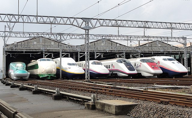
 JR East Shinkansen Lineup at Niigata.
JR East Shinkansen Lineup at Niigata. Image copyright Rsa, CC-BY-SA 3.0 Unported, available on the Wikimedia Commons.

Now, coming back to India

Mumbai is situated at an altitude of 14m above mean sea level, while Ahmedabad is located at 54m. Between the two cities, there is no rough terrain, but a simple incline. Rivers on this route include the Ulhas River, the Narmada, the Tapi, the Mahi and the Sabarmati. Major cities on the route, not counting the fact that the Southern termini is the Financial Capital of India, include Surat, India’s Diamond Hub and Vadodara.

The distance between Mumbai Central and Ahmedabad Junction is 493km, and presently takes 6 hours 25 minutes at a cost of ₹1000 for an AC chair car and ₹1900 in an AC Executive Chair Car in the fastest train on the route – The Shatabdi Express. Between Mumbai Central and Borivali, it runs slower than a Fast Local, taking 29 minutes for the journey, while a local takes 27 minutes, mainly due to congestion on the network. There are around 70 trains on this route at present. The High-Speed Rail corridor will be 508km long and will feature a 21km undersea tunnel North of the Thane Creek towards Virar before coming back up and continuing elevated.

The impact of this line is something most detractors fail to see. Critics say that the line is being favoured because the Prime Minister and Railway Minister hail from these two states.  What they forget is that Mumbai to Ahmedabad is among the highest density corridors of passenger transport in a day. Apart from this, this route is part of the Delhi-Mumbai Industrial Corridor. The Government must seriously consider the extension of this line from Mumbai to Pune as well, thus connecting the two most important cities of both Maharashtra and Gujarat.

Further, the feasibility study has recommended that fares along this route should be the 1.5 times First Class AC fares, which is approximately ₹2200 right now on the Mumbai-Ahmedabad Duronto Express. This is quite reasonable for the distance, given the time it achieves this in.

In comparison, taking Private Metro Lines into consideration; we see that the two most expensive lines are Mumbai Metro 1, which charges ₹45 for 11km, Rapid Metro Gurgaon, which charges a ₹20 flat fare for 5km. It is obvious that the High Speed Rail will cost less than most skeptics assume.

A study by IIM-Bangalore has come to the conclusion that in order to break even and prepay loans, the train would have to carry 88,000 to 118,000 passengers per day, at an approximate travel cost of ₹5 per km per passenger. This, with a little extra calculations, results in a single one way journey coming up to ~₹2600.

A while ago, Delhi Chief Minister, Arvind Kejriwal, the man who came up with the brilliant Odd-Even formula for Delhi, estimated that it would cost ₹75,000 for a one-way ticket for this journey, one which multiple people have tried to justify from an economic viewpoint on Quora. Both are wrong, for reasons known to all. For starters, Kejriwal is the CM of Delhi, not Maharashtra or Gujarat, where the line is to come up, nor is he the Railway Minister or an Economist. Two, the deal that Japan and India have agreed to is not what everyone is using for their calculations.

Japan is giving India a loan of ₹79,000crore at an interest rate of 0.1%, with India having to pay back this loan over a 50 year period with a 15 year moratorium prior to that. In common language, India starts paying the loan back 15 years after the loan period begins. This is cheaper than the Delhi Metro’s JICA loan. A propaganda article by Troll.in, sometimes masquerading as Scroll.in calls it a Wasteful Expenditure. Why? It fails to mention that the money will be spent over 7 years, and not one year as the article claims. As stated, haters will continue to hate, in spite this particular corridor having been sanctioned by the previous government.

Why not Conventional Rail?
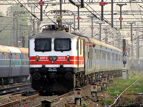
The Bhopal Shatabdi Express, with LHB Coaches, is the fastest train in India with a top speed of 150km/hr.
The Bhopal Shatabdi Express, with LHB Coaches, is the fastest train in India with a top speed of 150km/hr. Image copyright Ayushrocks, Public Domain.

This is an often asked question. People ask, why not improve the existing rail network?

Simple, Japan is offering the loan for export of the Shinkansen ONLY. It will also transfer some Technology to us so that we can use it for future lines. This money cannot be used for any other purpose.

This does not meant that the Conventional Railway Network will take a backseat or be discontinued. It just means both will coexist. Like a Bus Transport company has Regular and AC services.

But then, why not Maglev?

Shanghai Maglev Train.
Shanghai Maglev Train. Image copyright JakeLM, CC-BY-SA 2.5 Generic, available on the Wikimedia Commons.

Another often asked question here is: Why not Magnetic Levitation aka Maglev, which offers speeds of upto 431km/hr against the Shinkansen high speed of 320km/hr?

China uses a Maglev in in Shanghai. The line is a completely elevated one connecting the city and its airport. In a Maglev, the tracks are designed in such a manner that the train glides over it. Thus, the entire system is automated and both the tracks and the train itself are run by Computers. The Shanghai Transrapid was built by many companies. The tracks were built by local Chinese firms, while the train itself is German, having been built by ThyssenKrupp and Siemens.

Cost of investment is high, as high or higher than the Shinkansen, but not at the same cost of the Shinkansen, keeping in mind the loan and the associated conditions.

The Bottom Line

The Bullet Train between Mumbai and Ahmedabad is crucial for the Nation. It would help in redrawing the lifestyle and work culture of India, as well as restructure Western India as a transport hub. The biggest beneficiary of this would be Diamond Merchants in Surat, and along with that, the Smart City projects of GIFT City, DREAM City, and the Dholera SEZ.

Other routes that should be considered:

  • Chennai – Bangalore – Mangalore
  • Chennai – Coimbatore – Cochin
  • Delhi -Gurgaon – Jaipur
  • Pune – Hyderabad – Vijaywada

Also Read: What The Mumbai-Ahmedabad Bullet Train Means For The Region on Swarajya.

Save

Loading

Flattr this!

Mumbai – Drive, Design and Connect

Mumbai. Bombay. Bambai. The City that Never Sleeps. Maximum City. Or, as I like to call it, BEST City.

The city of Mumbai, along with its satellite townships of Thane, Navi Mumbai, Mira-Bhayander, Vasai-Virar, and Kalyan-Dombivali forms the Mumbai Metropolitan Region, which is India’s second largest urban agglomeration and largest conurbation in a single state in the country. Other major Metropolitan regions in the country include the Tricity area of the Union Territory of Chandigarh, Mohali in Punjab and Panchkula in Haryana, and the National Capital Region consisting of the National Capital Territory of Delhi, Gurgaon, Faridabad, NOIDA, Ghaziabad, etc. Neither of these two is in a single state unlike the MMR.

However, what makes the MMR unique is the variety that is present across one single state. Maharashtra, being the state with the most decentralised administration, doesn’t control the MMR as much as the local Municipal bodies do. Each Municipal Body controls Transport in its jurisdiction, along with other factors such as water supply, electricity supply etc.

So what maketh Mumbai #MadeOfGreat ???

Roads. Rail. Buses. Beaches. Add to it, we have India’s first open-to-sea Cable-stayed bridge and also are the proud starting point of India’s first Expressway.

So, now, let us go into the nitty-gritties of what makes Mumbai the most amazing city.

Drive

Western Express Highway, Mumbai.
Western Express Highway, Mumbai. Image copyright Nicholas, CC-BY-SA 3.0 Unported, available at Wikimedia Commons.

Mumbai offers some amazing roads for you to take out your Tata, Toyota, Maruti, and Mercedes. You have the Western Express Highway, Eastern Express Highway, Sion Panvel Highway for your car to stretch its tyres. If you want the scenic route, you have Marine Drive, the Worli Seaface, Bandra Worli Sea Link, Eastern Freeway, Palm Beach Marg, and more. Of course, you do have the Toll Plazas, but if you have a FASTag, you can zip thru with ease. If this wasn’t enough, the city is the only one in India to feature a Road tunnel WITHIN the city! Mumbai also happens to be the city with maximum disciplined traffic. You’ll see people drive neatly in lanes, and give preference to pedestrians. The city also has long Skywalks, mostly connecting Railway stations to other areas, allowing Pedestrians to walk without having to put up with traffic.

DESIGN

Mumbai is probably India’s ONLY Linear city. The core city is divided into two parts, the Island City also known as Town,  and the Suburbs, known as Greater Mumbai. Autos are prohibited in Town, which also houses some of Mumbai’s longest flyovers. Dr. Ambedkar Marg, the southern extension of the Eastern Express Highway features the 2.9km Lalbaugh flyover at Parel, which was built higher than most flyovers to allow the procession of the Lalbughcha Raja during Ganesh Chaturthi. The 2.4km long JJ Road flyover at Byculla was among the first in the country to use Noise barriers. The suburbs have the two main highways, along with SV Road, LBS Marg and numerous link roads such as the Jogeshwari Vikhroli Link Road, and the Santacruz Chembur Link Road, which features the city’s first Double Decker flyover.

Navi Mumbai, India’s most amazing planned city was built in the 1970s by the City and Industrial Development Corporation [CIDCO] to decongest Mumbai. It is a planned city, stretching from Airoli in the North to Panvel in the south. It was planned and designed by Charles Correa, and features some amazing railway stations. Vashi station has an IT Park above the tracks, CBD Belapur station has a helipad atop it, and Turbhe Railway station was designed by Hafeez Contractor.

Flyovers in Mumbai feature public paid parking lots below them, or house Traffic Police Stations. The Khodadad Circle flyover, at Dadar Tram Terminus houses a Bus terminus under it. MSRTC’s conductorless Shivneri buses to Pune leave from here.

Transport aside, Mumbai features a lot of amenities and interesting facilities for the humans residing there. It houses two cricket stadiums, Wankhede and Brabourne, a football stadium at Cooperage for all the future Messi’s, and a large Indoor stadium at the National Sports Club of India [NSCI].  It features numerous cultural establishments such as the Chhatrapati Shivaji Vastu Sangrahalay, Bhau Da Ji Lad Museum, Jehangir Art Gallery and National Centre for Performing Arts.

CONNECT

Mumbai is home to India’s densest railway network. Comprising 465km of suburban lines, it is spread out across 6 lines. The city has India’s oldest railway network, and the maximum number of Terminus Railway stations. 2342 daily services from 4am to 1am carry approximately 7.5million passengers in a Day! Each train consists of Second Class, First Class, Women’s Second and First class coaches. Mumbai has a combination of trains, some with 9 coaches, some with 12 and some with 15! Air conditioned coaches will be inducted by 2016. Mumbai is the head of two railway zones, Western and Central and houses India’s most magnificent railway terminus, the Chhatrapati Shivaji Terminus, which is a UNESCO World Heritage structure. It is also the only city that has two Rajdhani Expresses connecting it to Delhi.


Mumbai Suburban Railway
Mumbai Suburban Railway. Image copyright Integral Coach Factory, CC-BY-SA 3.0 Unported, available on Wikimedia Commons.

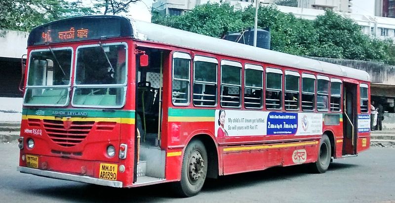
Mumbai has India’s oldest Public Transport system, in the form of BEST, which has been operational since 1873. It is right to say that Mumbai had Public Transport when the rest of India did not know what Transport meant. The BEST provides buses that connect to all other parts of the city and most of the metropolis. BEST is today, the only Transco apart from the Kerala State Road Transport Corporation that operates Double Decker buses, and makes use of the Bell Pull on all its non AC fleet. BEST is also the only transco to feature a single-door Volvo B7RLE.

BEST Bus No. 56 at Versova Yari Road Bus Station.
BEST Bus No. 56 at Versova Yari Road Bus Station. Image copyright Srikanth Ramakrishnan, CC-BY-SA 4.0 International, available on the Wikimedia Commons.

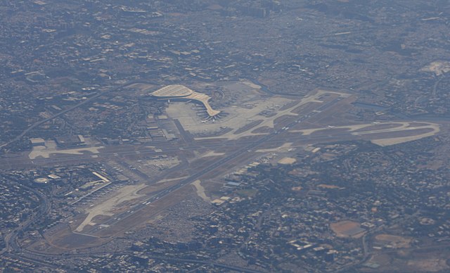
Mumbai also has India’s oldest airport at Juhu as well as the second largest airport in the country, that also has the current tallest Air Traffic Control tower. Again, the city had air transport when the rest of India wanted to know how planes fly. It was from here that JRD Tata first flew in 1932, four years after it opened.

Mumbai Airport as seen from above.
Mumbai Airport as seen from above. Image copyright Andrew Thomas, CC-BY-SA 2.0 Generic, available on the Wikimedia Commons.

India’s first expressway connecting Mumbai and Pune starts from Panvel, while the Eastern Freeway, and Sion Panvel Expressway offer great drives and greater escape routes in the city.


Tata Motors has signed up Lionel Messi as its brand ambassador and I think that is a great move!


Zonal War Winner WEST Zone

Loading

Flattr this!

The BEST way to Imagica

Please Note: BEST has discontinued services to Imagica a long time ago. You can check Imagica’s official website for more details on their buses: 

Click here to go to the Imagica website’s page for bus trips to and from the park

Also; do consider getting a pair of these socks:

BEST recently announced that it would ply AC services to Imagica.

Yep, you heard that right. BEST, which has been incurring heavy losses for several years now, has decided it will ply AC buses to Imagica. Apart from this, BEST has managed to get Diamond Traders to sign a ₹80,000 agreement for bus services from Andheri to Seepz.

BEST is also looking at tying up with IPL to provide bus connectivity to stadiums during matches, something that BMTC has been doing for the past few years.

BEST also announced that they were in talks with Essel World to provide buses.

The bus to Imagica leaves from CST at 7am in the morning and costs ₹500 for a round trip. Tickets can be booked the previous night on Imagica’s website.

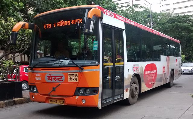
Now, the question is, what buses is BEST using? Since it is a weekend bus, they can probably use the Volvo on Sunday when AS-4 is not operational.

A BEST Volvo on Route AS-4 from Backbay Depot to Oshiwara Depot.
A BEST Volvo on Route AS-4 from Backbay Depot to Oshiwara Depot. Image copyright Srikanth Ramakrishnan, CC-BY-SA 4.0 International, available on the Wikimedia Commons.

Using them Purple Faeries on this route, would severely ruin BEST’s image as only a handful of them are good, mostly from the Oshiwara Depot.

A BEST Cerita running on route AS 461. Also known as them Mumbai Purple Faeries.
A BEST Cerita running on route AS 461. Image copyright Srikanth Ramakrishnan, licenced under CC-BY-SA 4.0, available on the Wikimedia Commons.

The BEST must not make the BMTC mistake however. BMTC rents out its newer Volvo buses to corporate bodies such as Manayata Embassy Business Park [MEPB] and the Outer Ring Road Companies Association [ORRCA] and leaves the older, much older KA-01-FA series Volvo buses for the public to use. This is a good opportunity for BEST to resurrect the pathetic image that the AC fleet today has earned and replace it with the Premium luxury one that MSRTC enjoys for itself. BEST must ensure that all six Volvo buses don’t go for corporate trips leaving us at the mercy of the Purple Faeries. The Volvo buses must continue running on AS-4 and be used on the Fort Pheri services instead of idling at Backbay Depot. Similarly, BEST can use the AC buses that arrive at Colaba Depot as AS-9 on similar ring routes in SoBo with a subsidised fare to make them lucrative. This is needed, to keep the fleet running.

All said and done, I’m now excited at the prospect of seeing a BEST bus on the Mumbai-Pune Expressway and hope to get to click a photograph soon.

Route and schedule

The BEST Bus to Imagica leaves CST at 7.15am. The following are it’s pickup points and their timings:

  1. Mumbai CST at 7.15am. [Bhatia Baug Bus Station]
  2. Bhendi Bazar at 7.25am. [Route No. 1 Bus Stop]
  3. Byculla Station at 7.35am. [Route No. 1 Bus Stop]
  4. Jai Hind Cinema at 7.45am. [Route No. 1 Bus Stop]
  5. Lalbaug at 7.50am. [Route No. 1 Bus Stop]
  6. Parel TT at 8.00am. [Route No. 1 Bus Stop]
  7. Dadar TT [Khodadad Circle] at 8.10am. [Route No. 1 Bus Stop]
  8. Maheshwari Udhyan at 8.15am. [Route No. 504 Bus Stop]

Arrival at Adlabs Imagica at 10.30am.

Tickets can be booked on the Adlabs Imagica Website.

Buses from Borivali are provided by Neeta Travels. Who knows, this might be BEST soon.

Loading

Flattr this!

The Hangman Returns

So, at the beginning of this month, it was announced that CIDCO and NMMC were planning a Cable Ropeway from Shivaji Showk, Vashi Bus Station to Teen Taki Chowk, Kopar Khairane Bus Station.

So, barely two weeks later, it turns out that CIDCO gave an in-principle approval to Tata Realty and Infrastructure Limited [TRIL] to prepare a Detailed Project Report [DPR] for the project. If approved, this would be done on the “Swiss Challenge” method, wherein when a tender is floated, in which TRIL will have the right of first refusal and get an opportunity to match the best offer.

Along with this, a new route has been proposed. Now here’s where it gets interesting. The new route, has been proposed from Vashi to Ghatkopar. Yes, you read that right. Vashi to Ghatkopar, across the Thane Creek. The proposal is to connect it to the Metro at Ghatkopar [which seems nearly impossible given that there is no land available near Ghatkopar]. However, it would be marginally easier to connect it to the Monorail. Or better. Connect it to Ghatkopar Depot. Get on to them Purple Faeries on AS-388 to Poisar Depot.

Now, what seems to be the problem here?

  1. Building a set of pillars for a ropeway from Vashi Bus Station to the Vashi Creek.
  2. Building a set of pillars in the wetlands occupied by mangroves on both sides of the creek.
  3. Building a set of pillars on the actual creek.
  4. Crossing the Eastern Express Highway, building in Ghatkopar, and reaching the station.

So at the end of the day, this will be a super problematic thing to build. However, if they are able to build it, I, for one, would be super happy.

The issues here are:

  • Permissions to build over wetlands and the creek itself.
  • Variations in height. Most Ropeways/Cable Cars have a fixed gradient. This stretch would require the alignment to go up and down multiple times.
  • Turns. Again, most systems have a straight route. This one would require zig-zags.

However, the Vashi to Kopar Khairane plan is a brilliant idea. For starters, it would ease traffic on the Trans-Harbour line, the Thane-Belapur Road, as well as the Vashi Bus Station Road. Besides this, it will also provide a brilliant an scenic view of the entire city. While in most parts of Mumbai, the West saw development, in Navi Mumbai, barring Nerul and CBD Belapur, it was mostly the East, along the Highway that grew faster. It’s time to revolutionise our nations’ transport systems, and what better way to do it than the Mumbai Metropolitan Region!


Loading

Flattr this!

A Smarter BEST for a Smarter Mumbai

This can be taken as a continuation of two earlier posts, BEST Limited and NMMT Limited.

BEST Bus No. 56 at Versova Yari Road Bus Station.
BEST Bus No. 56 at Versova Yari Road Bus Station. Image copyright Srikanth Ramakrishnan, CC-BY-SA 4.0 International, available on the Wikimedia Commons.

Recently, BEST made an announcement that it would enable users to track a BEST bus live using a phone app.

Public Information System / Intelligent Transport System

Now, I am going to start by introducing BEST’s Public Information System [PIS], also known as Intelligent Transit System [ITS], that I had attempted to explain in my post on Electronic Ticket Systems. As stated earlier, each bus stop in BEST is numbered. This number is used to identify the buses that stop at that particular bus stop and is used to determine the ETA of the buses that are arriving at that stop. This number also ensures that each stop is unique and in the database, so that the conductors can enter it on their ETMs. While, there may be two or more bus stops, adjacent to each other, sharing the same name, each bus stop caters to different buses and has a different Stop Code. However, for a particular bus, only one of those stops matters and thus, there is no confusion for the conductor as well.

In partnership with several firms, including Trimax IT, Verve Compusoft, Overtures Infotech, the BEST PIS is visible at its website http://bestpis.in.

Each bus is fitted with a set of GPS devices that are present above the drivers’ seat. This helps coordinating the location of the bus and transmitting the location to the server.
So, now:
At 9.10am on 8 September 2015, I sent
BEST 07187 as an SMS to 56060.

I promptly got a response with the following:

NEHRU PLANETARIUM STOP : 003AS ETA 09:41,004AS ETA 09:41,033 ETA 09:44,305 ETA 09:48,592AS ETA 11:07,086 ETA 13:01,, Powered by Verve Compusoft Pvt. Ltd.

Here, 07187 is the stop code for the last Bus Stop towards Tardeo at Nehru Planetarium, where AS4 and A74Express stop. The response may be a bit confusing if it is the first time you are reading it, but here is what it means:

Nehru Planetarium is the name of the stop. The Expected Times of Arrival of the following buses are:

  • AS-3 at 9.41am
  • AS-4 at 9.41am
  • 33 at 09.44am
  • 305 at 09.48am
  • AS-592 at 11.07am
  • 86 at 1.01pm.

Of course, do note that this doesn’t mean that the next 86 is going to come after 4 hours, it merely means that the next 86 with  working GPS device is that far. It could also mean the system is faulty, since it was showing an ETA of 3.42am for AS-4 last night.

Now, BEST plans to integrate the existing system with a map that will show the exact position of the bus, live, on the map. While I personally feel this is a great move, BEST should also use this opportunity to ensure that all its buses are taken into consideration.

Stop Information System

This was something that started with the Jawaharlal Nehru National Urban Renewal Mission [JnNURM], now replaced with the Atal Mission for Rejuvination and Urban Transformation [AMRUT]. Under this, all buses were fitted with three exterior LED displays, one at the front of the bus, one on the side and one at the rear to display the route. While cities like Bangalore, Chennai and Mysore alternatively scrolled English and Kannada/Tamil on these displays, and Coimbatore showed only Tamil on all displays, BEST decided to have only Marathi on the front display, with English on the other two displays. A fourth LED display was present inside of the bus, behind the drivers area. This panel would display the upcoming stops, accompanied by an announcement. In most cases, they rarely work. They work in most of the older Blue-coloured JnNURM BMTC buses where they display the destination and the next stop. These systems work excellently in the Ahmedabad Janmarg as well as PMPML Rainbow. In BEST, I have experienced this only once, back in 2012, when I was in an AS-505 between Bandra Bus Station and CBD Belapur Bus Station. This system works with GPS too. However, it is nonfunctional on most BEST buses today, and needs to be revived soon.

Bus Identification System

Now this may come as a surprise to many, including my fellow BEST users, because it is not a very well known system. Some people may have seen it in a few buses that are part of Backbay Depot.

OnBoard Bus Identification System for Visually Impaired Passengers on a BEST Bus of the Backbay Depot.
OnBoard Bus Identification System for Visually Impaired Passengers on a BEST Bus of the Backbay Depot. Image copyright Coolguyz.

This device is called OnBoard, and is jointly developed by the Xavier’s Resource Centre for Visually Challenged (XRCVC), in collaboration with Assistech of IIT-Delhi. It was tested first by BEST in two buses in February-April 2015 and then tested out in DTC. From what I gather, the system requires a visually impaired person to activate a switch which then informs them of any approaching bus. The box is fitted on the window frame next to the single seat up front. I believe this has scope to connect to the existing GPS set-up in order to make it automated, so when the bus reaches a stop, it gets triggered on its own. So, imagine if someone is waiting at World Trade Centre, for Bus No. 134. A bus fitted with OnBoard arrives, detects its location, or synchronises itself with the Bus Stop [a slightly expensive, difficult to maintain, but more efficient system] and it announces to the passenger: बस क्रमांक १३४: बॉकबे आगार ते प्रबोधनकार ठाकरे उद्यान शिवडी , followed by Bus Number 134, Backbay Depot to Prabodhankar Thakre Udyan Sewree. This would be great in my opinion.

This would be BESTs second attempt at trying improve accessibility for disabled passengers, with the previous one being the induction of the Ultra-Low-Floor Tata Starbus in 2004 with automatic doors and ramps for wheelchairs.

At the end of the day, BEST has done a good job at trying to do what it is supposed to do: Be a Transport Undertaking that caters to the Passengers, rather than try and rake in money, which is what NMMT , TMT, and mainly the BMTC seem to be doing.  BEST was among the first transcos in India to reserve seats for women, senior citizens, physically-impaired commuters, and charge visually-impaired commuters a flat fare of ₹2 [earlier ₹1].

A smarter BEST, one that is able to cater to its commuters effectively, will most certainly help in making Mumbai a smarter city.

What are your thoughts?


Loading

Flattr this!

Bums on the Saddle

Since time immemorial, cycles have been a very important mode of transport. They are used for various purposes, from acting as a “business hub” in terms of acting as a point-of-sale for tea vendors to the main business vehicle in rural areas. They are used as the main transport vehicle by many, especially in rural and semi-urban areas. In urban and metropolitan areas, they are viewed as a lower class mode of transport.

Cycles acting as a Business Hub. A vegetable Vendor in Sathyamangalam, TN, uses his cycle as his shop.
Cycles acting as a Business Hub. A vegetable Vendor in Sathyamangalam, TN, uses his cycle as his shop. Image copyright Srikanth Ramakrishnan, CC-BY-SA 3.0 Unported, available on the Wikimedia Commons.

In the recent past, several cities in India have tried to popularise cycling in several ways. Among them are Pune, Bangalore and Ahmedabad. While some have succeeded and some have failed, it is worth relooking at cycling for the various benefits it offers.

A board indicating a Cycle Track in Pune.
A board indicating a Cycle Track in Pune. Image copyright Mahendrapatnaik, under the CC-BY-SA 3.0 Unported licence on the Wikimedia Commons.

Pune got cycle lanes around 2008 while the city got a massive overhaul for the Commonwealth Youth Games, under the JnNURM pattern. A few cycle tracks were laid in and around Kothrud and Shivajinagar, while majority of the cycle lanes were laid from Katraj to Swargate to Hadapsar alongside the first BRTS line. These cycle lanes are usable, but they are usually blocked by traffic, pedestrians, or sometimes, hawkers and homeless people.

Bangalore got cycle lanes in 2012. These lanes are prominent in and around Jayanagar, especially under the Metro. These lanes were basically just a section of the road marked with a solid white line with the image of a cycle painted on it, thus not having a physical barrier separating it from regular traffic like the ones in Pune. The net result, they turned into parking spaces for cars.

Mysore too got cycle lanes, but unlike Bangalore, they were physically separated from motorised traffic.

However, a year prior, in 2011, prior to the opening of the first Reach of Namma Metro, Bangalore also got a Public Shared Cycle system, jointly operated by the BMRCL and BBMP. The system was operated by Kerberon Automations under the brand name Atcag. Each cycle was tracked by GPS and required users to pay a one time registration of ₹1000 for a smart card and then use the card as a prepaid card while using the cycles. The first hour was free, after which a nominal rate would be charged. There were 9 cycle stations in the city.

Ahmedabad got a similar system named MyByk, operated by Greenpedia, with cycle stations across several Janmarg stations.

Cycles for use by everyone inside the Infosys Mysore Campus.
Cycles for use by everyone inside the Infosys Mysore Campus. Image copyright Prateek Karandikar, CC-BY-SA 4.0 Unported, on the Wikimedia Commons.

Now, the success of the public share and ride system is entirely debatable, mainly due to the subscription based nature of the service. The system followed in IT parks like Infosys, or college campuses like the IITs, where a cycle is picked up from the stand and left in another is impractical in public because cycles will get damaged or stolen because the rider is not being held accountable for their actions. Thus, the system of charging users and tracking the cycles, both with GPS and tying it to a user is a necessity.


Now, the main section. How do we implement an effective cycling plan across major cities. For this purpose, I plan to use the Pune Metropolitan Region of Pimpri-Chinchwad and Pune, as well as a part of the Mumbai Metropolitan Region consisting of Mumbai, Navi Mumbai and Thane.

Creating cycle tracks and lanes is one thing, but making it safer for cyclists is more important. Cyclists are on par with Pedestrians. Both are treated badly and often traffic doesn’t bother stopping for them, even with the appropriate traffic signals showing.


Our first target, the PMR.

The Pune Metropolitan region offers immense potential for cycling as a mode of public transport. This, coupled with the fact that Pune has been the undisputed Cycling Capital of India for a long time makes one wonder why the government has not done much to promote cycling. For starters, all the BRTS corridors, from Nagar Road, Nashik Road, Aundh-Ravet Road, Vishrantwadi Road, et al must be given proper cycle lanes. Once this is done, cycle parking must be provided. This can be easily achieved at major bus terminals such as Kiwale and Vishrantwadi, but needs to be given a serious thought at other areas. It can be done with relative ease at Kalewadi Phata and Dange Chowk, both of which have a split flyover, providing the much needed space for the parking. Similarly, parking must be offered at major PMPML bus stations, such as Kothrud, Balewadi, Nigdi, Chinchwad, Corporation, Pune Railway Station, Swargate, Hadapsar, etc, as well as Railway stations like Shivajinagar, Kasarwadi, Akurdi etc. Along with this, last mile connectivity should be provided for those using shared cycles. Docking stations must be provided in residential pockets to encourage their use.

And now, for the MMR.

The situation in the MMR is pretty similar to the PMR. Cycle stations can be provided at all of BESTs Depots, Bus Stations, major junctions such as Rani Laxmi Chowk, Khodadad Circle, Dr. Shyama Prasad Mukherjee Chowk, NSCI Worli, as well as under the various rail-based stations. Cycle stations can be built around the Railway stations as part of SATIS, or under Metro and Monorail stations on the Median with an additional staircase of elevator for cyclists to use. In Thane, Navi Mumbai, it can be implemented along several select areas near Hiranandani along Ghodbunder Road, and at all CIDCO railway stations. It would be a massive boon to have it at CBD Belapur Railway station given the connectivity it will soon receive. A cycle station can be set up under the CBD Belapur flyover as well. Similarly, stations must be built at all present and upcoming Jetties, Ferry Wharf, Gorai Jetty, Belapur Hoverport, etc. Other major areas where they can come up are at SEEPZ in Andheri, Powai, etc.

Bangalore and Chennai

Both these cities should seriously consider providing cycle stations at bus stations, railway stations and Metro stations. This might help fulfill the BMTC Park and Ride Concept.


Now, for the bigger problem. The Cycle Stations themselves. How should they be built and operated:

Ideally, each ‘Cycle Station’, should consist of two parts: One for the public cycles, and for people riding their own.

The former is not a problem, since each user requires a Smart Card. Thus, authentication and security are sorted as both are connected to the card.

The latter, however might turn out to be a bit of a problem. Unlike a regular Pay-and-Park system, Cycles need a little more. Stealing a car, or a motorised two wheeler, is not too easy, whereas here, it is as easy as lifting a box off the ground and then pushing it out. So how do we solve this problem? Simple, we provide a locking mechanism on the cycle stand. But how would you make it work? There are two methods I see for this:

  • The Old Fashioned Way: Hire a guard or attendant. He gives you a receipt for the parking charge, you park it in the stand, lock it with your own lock and go. You can have a pass system for this. For those who don’t have a lock, provide one against payment of a refundable deposit. Say your parking charge is ₹20 for a day, you charge ₹50 for a chain and lock, upon whose return, you get your money back. You can have a daily-weekly-monthly pass system for this as well. It’s a win-win situation. Print the cyclists photo and a photo of the cycle, specify the date and time details for the pass on a sheet of paper. Just cross the date if it is a daily pass being sold by the vendor. It is as simple as a conductor selling a ticket. But do we really want to go down this path? Especially with Digitisation and eGovernance coming up?
  • The High-Tech Way: Install cameras for security, but yes, do hire a guard. Every user needs to have a smart card, for single transactions, they can get a token or a single use paper RFID token. The user comes in, locks the cycle with a lock built-into the stand, swipes their card on the sensor and leaves. The money for the parking is deducted from the account balance of the card. For the ones who don’t have a card; keep a machine like the Automatic Ticket Machines at Metro Stations. User slots in the time they intend to park for, insert the money, collect the RFID token or printed ticket, lock their cycle and go. On return, they return/slot-in/swipe the card or token and take their cycles out. This can be a good starter with the BEST prepaid card as the Smart Card.

There is a lot of thinking, planning, redrawing, mapping, innovating to be done to implement this. This will potentially improve and increase the number of cyclists on the roads, which might help reduce traffic jams. We all know how healthy and enjoyable cycling really is. Let us share the joy with those who may not know.


Do post your feedback in the comments below:


Save

Save

Loading

Flattr this!

The changing face of Mumbai’s Taxis

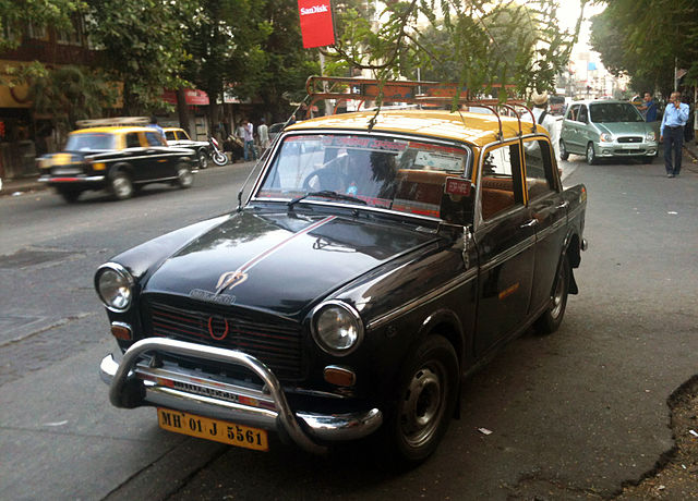
Most of us associate a taxi in Mumbai with just one entity: The Black-and-Yellow Premier Padmini. I’m going to attempt to track Taxis in Bombay to their current scenario.

A black and yellow Premier Padmini Taxi on the Streets of Mumbai.
A black and yellow Premier Padmini Taxi on the Streets of Mumbai. Image copyright Ask27, CC-BY-SA 3.0, available on the Wikimedia Commons.

These cabs have been on the roads for decades and have remained the undisputed maharajas of South Bombay. They had competition from only one other entity; the Cool Cab. The Cool Cab is a better vehicle; often a Santro, Indica, or a WagonR. They are Blue in colour and air-conditioned. Naturally, their fares are higher.

A Blue Cool Cab on the Streets of Mumbai.
A Blue Cool Cab on the Streets of Mumbai. Image copyright Ask27, CC-BY-SA 4.0, available on the Wikimedia Commons.

Taxis first made their appearance in the city in 1911, to complement horse-drawn carriages. Traditionally, these taxis operate in the same way taxis operate across the world. The driver gets a Transport-Vehicle licence. Either the driver, or the owner buys the vehicle, approaches the Regional Transport Authority [RTA] for a commercial registration and a Taxicab permit. Then the vehicle is registered to one of the Unions operating under the jurisdiction of the Mumbai Metropolitan Regional Transport Authority [MMRTA].

Under Maharashtra regulations, a cab, like an auto cannot refuse a fare. As long as the Fare-Meter says ‘For Hire’ on it, the taxi driver has to take the commuter to their destination.

For years, these taxis [along with the blue counterparts] remained the primary for-hire service in the city, especially the South, where Autorickshaws are banned to reduce congestion.

The first step towards change, was in 2007 with the appearance of the Fullora Gold Taxi. The Fullora Foundation was an NGO that set up the Mumbai Gold Cab Company. Regular taxi owners were invited to join the company. The deal included the sale of their old Premier Padmini, getting ₹25,000 in hand, shares in the company, a new taxi as well as insurance. A move that the Mumbai Taximens Union vehemently opposed. Among the various reasons to oppose it, the Taxi Union stated that the plan would fail as they would not have a taxi stand and would operate round the clock. When launched, they had a fare lower than that of the standard Cool Cab. The fleet was composed of Esteems, Indigos and similar saloons.

A Fullora Gold Cab in Mumbai.
A Fullora Gold Cab in Mumbai. Image Copyright Mumbai Gold Cabs, All Rights Reserved.

The period witnessed a boom in private cab operations with other players such as Meru, and the all-women Priyadarshini and Forsche joining the bandwagon.

What did this mean for the Common Man in Bombay?

Private cabs can be called when needed. This eliminates the need to look out for a taxi stand. They are mostly monitored by GPS. This makes it easy to track the cab. What really made me happy is the advent of Women-only cabs. Forsche [now Viira] and Priyadarshini cabs. Giving women drivers opportunities, and of course, women passengers feel safer that way.

What happened then?

By 2010, the market was saturated with many call-taxi operators, many of whom had pan-India operations, such as Meru, Mega Cabs, Easy Cabs, TabCabs, et al. The regular black-and-yellow as well as Cool Cabs continue to operate today, as do the Gold Cabs. Somewhere in 2011 Ola Cabs appeared on the scene as a taxi aggregator service. This was followed by Uber and other services. Surprisingly, however, Mumbai was fifth on Uber’s list. Ola and its subsidiary TaxiForSure [TFS], later on tied up with autos to allow you to find an auto on the spot with the app. TFS also launched Tata Nanos in Bangalore, although these are yet to be seen on the streets of Mumbai. Soon, others such as Meru, and TabCab too, lanched their mobile apps.

The scenario today:

The scenario today is rather simple.  If you are in SoBo, you can hail a cab as easy as hailing an auto. Autos and Taxis, traditionally in Bombay have been honest, and rarely overcharge. However, if one is not carrying cash, then an Uber, or Ola would make sense, particularly due to the extremely low fares they charge from their users. Cabs, in the long run do help get user of private vehicles off the streets, but they are among the reasons why BEST is reducing its AC fleet. Its good to see technology being put to good use, for the benefit of the consumer, be it prepaid wallets and Mobile Apps for booking, or Prepaid RFID cards for buses.


Loading

Flattr this!

26 July: Did we learn anything?

It has been exactly 10 years since Mumbai was inundated on 26 July 2005.

A flooded street in Mumbai with a BEST bus on it.
A BEST bus on a flooded street. Image copyright Hitesh Ashar, CC-By-2.0, available on the Wikimedia Commons and Flickr.

What have we learned from this event? Every year since 2005, there has been atleast one day in July [sometimes June] when the city comes to a complete standstill because of the flooding.

There are five major rivers in Mumbai, the Oshiwara, Poisar, Dahisar, Mithi and Ulhas. While the last one doesn’t exactly touch Mumbai per se, Salsette island lies on its Mouth, which makes it equally important, if not to Mumbai, then to the remaining areas of the metropolis, such as Thane, Kalyan, Karjat, etc.

The Mithi is the most talked about river in Mumbai. Sometimes, referred to as the Mithi Nala, it originates by the confluence of water discharges from the Vihar and Powai lakes,  flows south, passing under the Runway at Chhatrapati Shivaji International Airport before emptying out into the Mahim Bay. Now, throughout the course of the river, the Mithi, as are most other rivers passing through an urban area [except perhaps the Sabarmati in Ahmedabad], is subject to a huge amount of pollution. Pollutants in the Mithi come in the form of industrial waste, human waste, animal waste, and the ever-present, littering. This results in the river being toxic through much of its course, and being clogged with plastic and other such substances, just makes things worse. However, the last ten years have seen a lot of improvements. The MCGM has done a lot in digging up and desilting the river, thus increasing its water-carrying capacity. This was achieved by partnering with several private firms and NGOs. The river also acts as a source of livelihood to anglers in the monsoons who catch fish. Due to the high dissolved toxic components in the river, the MCGM came up with a plan to pump in Oxygen into it. Many areas of the river now have concrete walls to prevent encroachements, as well as to ensure the uniform width of the river.

The Dahisar River, originating in the Tulsi Lake inside the National Park, flows for around 12km. It passes under the Dahisar Bridge, which at one point in time, was a cinematic background used by the industry. Polluted in the same way as the Mithi, a few residents associations joined hands to start cleaning it up.

The Oshiwara River, half the length of the Dahisar, originates in the Aarey Milk Colony, and flows west towards the Arabian Sea. A lot of buildings are said to have been built on the mouth of the river. It passes next to the BEST Oshiwara Depot. Among the various measures suggested to fix this river are conversion into a waterway, and generating biogas out of the sludge.

The Poisar River, again begins in the National park and proceeds to the west, passing next to BEST’s Poisar Depot. What is interesting is that the MCGM began its clean-up back in 2006 itself. A land exchange between the MCGM and the Government of Maharashtra enabled the widening of the river, thus making it less encroached. Towards the eastern side, concrete walls and other measures have been taken to keep the river unobstructed.

Now, this brings us to one major project that was meant to fix everything: BRIMSTOWAD.

The Brihanmumbai Storm Water Drain [BRIMSTOWAD] project was launched in 2007 to help fix the city’s Century old drainage system. Under it, the MCGM increased the capacities of more than 2/3rds of the drains in the city. Under BRIMSTOWAD, eight pumping stations were to be built. Among these, four at Irla, Haji Ali, Love Grove and Cleveland Bunder have beem put into action. The Mithi River was designed to accommodate 120mm/hour precipitation. Various measures are meant to be taken, but when is the operative question.

Powai Lake Overflowing in 2005.
The Powai Lake overflowing in 2005. Image Copyright Bhadani, CC-BY-SA 2.0, Available on the Wikimedia Commons.

Here, the Powai lake is bursting at its seams. The lake is full of water hyacinths. These flowers need to go, they ruin the lakes. They can be used to generate energy however.

All in all, the city seems to have done a lot to combat the rain gods, but it seems this has not had much of an impact of the rains. The MCGM, along with the National Disaster Management Authority [NDMA] both need to team up and find a solution out of this mess once and for all for Mumbai to flourish in the monsoons.
Given how bad and inefficient administration, bad coordination between city and state, have ruined the Civic infrastructure, turning the city into a Wannabe Venice every year, we must focus on cleaning up the rivers, if not for water yo flow, then atleast for transport purposes.


Note: This article is dedicated to a friend, who at the age of 8, braved the entire floods a decade ago.

Loading

Flattr this!